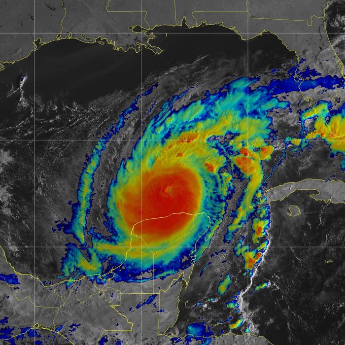
The warnings began arriving by telegram. A fierce hurricane had just swung around the western tip of Cuba and was heading for Tampa, Florida. When it made landfall at Tarpon Springs on October 25, 1921, it was the storm of the century. Winds of 120 mph smashed steamships and toppled trees, and an 11-foot storm surge swept away buildings and destroyed crops. At least eight people were killed. “Tampa City of Ruins,” a local newspaper declared.
It’s been more than 100 years since a storm this fierce has hit Tampa, but given the climatic trends, storms that formerly registered as once-in-a-lifetime events are going to be happening a lot more frequently. Hurricane seasons are getting more intense, researchers say, and outlier storms are getting bigger. So while Milton is going to be the worst storm that anyone alive has ever seen in the area, it might not be the last of its scale to come around for a while.
Jill Trepanier, a professor of geography at Louisiana State University, has studied the kind of extreme storms that only appear every 30 years. She found that as waters have gotten warmer, the intensity of these storms has increased. “Thirty years ago, when we thought about what a typical 30-year event looked like in Tampa, it was a Category 3,” she says. “Now, it’s inching toward Category 4.”
On the Saffir–Simpson scale, the standard gauge for measuring hurricanes, a Category 1 storm features sustained winds of 74 mph, while Categories 2, 3, 4, and 5 have winds of 96, 111,130, and 157 mph, respectively. Each increase in category corresponds to an exponential increase in energy. “There’s an incredible difference in the amount of damage caused as you go from one category to the next,” Trepanier says. While a Category 3 hurricane can result in “major damage” to well-built houses and power outages “for several days to weeks,” a Category 4 will cause “severe damage with loss of most of the roof structure and/or some exterior walls” of well-built houses and cause power outages that last “weeks to possibly months,”according to the National Weather Service.
Warm water is the fuel that drives hurricanes. A tropical ocean in late summer or early fall is a bit like a tinder-dry forest: a tremendous reserve of energy just waiting to be unleashed. In this case, the trigger is a disturbance, like a thunderstorm, that draws warm moist air higher into the atmosphere. As it rises, the moisture in the air condenses as cloud droplets, releasing heat, which causes the air to rise further still. This draws in more humid air from below, which then releases its own heat in turn. As the process accelerates, the pressure in the center of the newborn storm falls, drawing in new air faster and from further away. The rotation of the Earth pushes the inrushing air to the left in the Northern Hemisphere, and soon a spinning, sucking vacuum cleaner is trundling along.
As global warming puts more heat into the world’s oceans, more energy there is to feed hurricanes. How big they can get is a function of mathematics. In 1988 MIT meteorologist Kerry Emanuel published a paper in which he calculated that an ocean temperature of 86 degrees could theoretically yield hurricanes with a maximum wind velocity of 179 mph, with warmer waters yielding progressively stronger winds. (At time of writing, Milton is expected to make landfall with sustained wind speeds of 155 mph). An ocean temperature of 95 degrees could generate winds of up to 215 mph, rivaling the intensity of devastating tornadoes. “I think by the end of the century, if we don’t do a lot of curbing, it’s going to be closer” to this territory, Emanuel told the online journal Livescience.
We’re already moving in that direction. The first storm with sustained winds above 192 mph occurred in 2013. Since then there have been four more, prompting calls for the creation of a new designation, Category 6, for the new breed of megahurricanes. In a paper published earlier this year, climate scientists Michael Wehner and James Kossin argued that “the open-endedness of the fifth category of the Saffir–Simpson Hurricane Wind Scale becomes increasingly problematic for conveying wind risk in a warming world” and that “a number of recent storms have already achieved this hypothetical Category 6 intensity, and … more such storms are projected as the climate continues to warm.”
What’s of concern isn’t just how strong the biggest storms can get,but how many severe storms occur in a given season. Peter Pfleiderer, a climate researcher at the University of Leipzig in Germany, found in a 2022 paper that warming ocean temperatures had doubled the chances of “extremely active” hurricane seasons. “The potential for this storm to get a really damaging storm is just much, much higher because of the energy from the sea surface temperatures,” Pfleiderer says. It’s not just that the winds are stronger. “Every tropical cyclone that we see now is going to bring more precipitation and therefore higher chances of flooding, and with sea level rise, coastal flooding is going to be more intense,” he says.
The ocean near Tampa is particularly conducive to forming hurricanes. “The Gulf of Mexico has an incredible ability to manifest storms,” Trepanier says. “It’s exceptionally warm, and that warm water goes very deep, and it’s prolific throughout the entire Gulf.” Meanwhile, the factors that can reduce the intensity of a storm, like cold water or an extensive land mass, are largely absent. “It really has a solid setup,” she says. “We have all the ingredients we need to make a hurricane.”
To make matters worse for Tampa, its geography makes it particularly susceptible to hurricane storm surge and flooding. A 2015 study by Karen Clark & Company, a catastrophe modeling consultancy, found that Tampa–St. Petersburg is the most vulnerable metropolitan area in the country to storm-of-the-century hurricane damage, with potential losses of $175 billion, thanks in part to an offshore seabed topology that facilitates coastal flooding. “When a hurricane moves into shallower water closer to shore, the water is pushed up causing the storm surge,” the report said. “The shape of the coastline and the presence of inlets and bays also significantly impact the storm surge by creating a funneling effect. When water is forced into these narrow channels by the power of the strong winds, it has nowhere to go but up.”
That’s particularly bad news for the Tampa Bay area, where 50 percent of the population lives at an elevation of less than ten feet. The forecast for Milton currently calls for storm surge of ten to 15 feet. “Historic, catastrophic, life-threatening — all those words summarize the situation,” a National Weather Service forecaster told the Sarasota Herald-Tribune.
“It’s a beast,” Trepanier says. And while something of its like hasn’t been seen in a century, it’s reasonable to expect the next one won’t take nearly as long to come back around.
“What is the new normal?” Trepanier asks. “When we build structures, we build them based on our historical expectation, and that’s reasonable. However, when we actively are watching that threshold change, we need to be thinking about building what we need for the next generation, not for the conditions of the past. Because that’s no longer going to be sufficient.”


